-
×
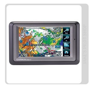 Garmin Aera 560
1 × د.إ9,599.00
Garmin Aera 560
1 × د.إ9,599.00
Subtotal: د.إ9,599.00

Aera 500 is Garmin’s first ever touchscreen aviation GPS portable, for easy transition from flying to motoring. By combining the best in moving-map display features with intuitive, menu-driven control, you’ll enjoy fingertip navigation on a crisp 4.3-inch QVGA wide-format touchscreen. Forget fiddly knobs and buttons, this flexible, feature-rich navigator provides streamlined operation for door-to-door guidance, not just runway-to-runway.
Physical and Performance:
Unit dimensions, WxHxD: 5.3″W x 3.3″H x .9″D (13.5 x 8.4 x 2.3 cm)
Display size, WxH: 3.81″W x 2.25″H (9.7 x 5.7 cm); 4.3″ diag (10.9 cm)
Display resolution, WxH: 480 x 272 pixels
Display type: touchscreen WQVGA colour TFT with white backlight
Weight: 9.5 ounces (270 g)
Battery: removable, rechargeable lithium-ion
Battery life: up to 5 hours (less with full backlight and options)
Waterproof: yes (IPX7)
Voltage range: 11-35
Receiver: high-sensitivity with WAAS position accuracy
IFR or VFR: VFR
Maps, Databases & Memory:
Basemap: yes
Navigation database (includes Jeppesen® data): yes
Types of Jeppesen data: full and ARTCC, FSS frequencies and final approach waypoints
Navigation database coverage areas: Atlantic
Preloaded Terrain database: yes
Preloaded Obstacles database: yes (U.S. and Europe only)
Preloaded SafeTaxi™ airport diagrams: not available
Preloaded AOPA Airport Directory: not available
Preloaded Garmin FliteCharts®: no
Preloaded low & high altitude enroute airways: yes
Preloaded private airports: yes
Preloaded street maps: yes
Ability to add maps: yes
Accepts data cards: yes (microSD™ cards)
Built-in memory: internal solid state
Waypoints/favorites/locations: 3,000 (aviation mode); 1,000 (automotive mode)
Routes: 50
Features:
Moving map: yes
Patented panel page: yes
HSI (GPS-based): yes
IFR map mode: yes
Traffic Information Services (TIS) alerts compatible: no
Audible terrain alerts: yes
Terrain resolution: standard
Smart Airspace Feature (generates and displays altitude-sensitive alerts): yes
Automatic logbook: yes
Separate serial and USB interfaces: yes
Voice prompts (e.g. “Turn right in 500 ft.”): yes (auto mode)
Speaks street names (e.g. “Turn right ON ELM STREET in 500 ft.”): yes (auto mode)
Lane assist (guides you to the proper lane for navigation): no
3-D map view: yes (auto mode)
Bluetooth® wireless technology: yes (auto mode)
Speed limit indicator (displays speed limit for most major roads in the U.S. and Europe): no
FM traffic compatible: no
Custom POIs (ability to add additional points of interest): yes (auto mode)
XM WX Weather & Radio for U.S. & Canada compatible: no
 04 3550600
 052 7036860

There are no reviews yet.