 04 3550600
 052 7036860
 info@techsouq.com
Garmin Montana® 750i Rugged GPS Touchscreen Navigator with inReach® Technology and 8 Megapixel Camera (010-02347-01)
Big news. A full QWERTY keyboard lets you easily type messages.
Wander wider and still stay in touch — with inReach for messaging and 24/7 SOS.
Nav, meet cam. Put your trip pics on the map with geotags.
Routable TopoActive Europe maps. Now you’re free to take it off-road or on.
Meets MIL-STD 810 for thermal, shock, water and vibration.
Power your adventures with 18+ hours of lithium-ion battery life in GPS mode.
AED4,999.00
SEE THE WORLD. STAY IN TOUCH.
BE THE PICTURE OF ADVENTURE.
The rugged Montana 750i handheld combines the flexibility of on- or off-road navigation with global messaging and interactive SOS via inReach satellite technology1 — plus a built-in 8-megapixel camera.
Stay in touch off-grid with inReach technology.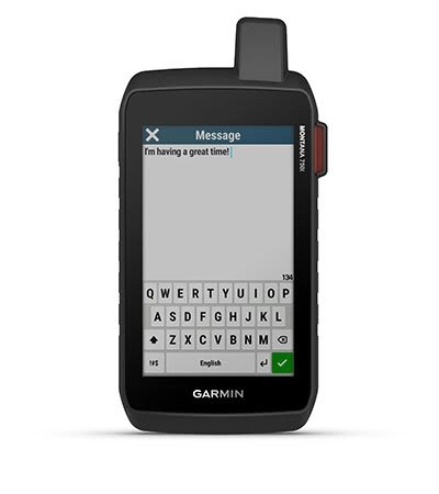
TWO-WAY MESSAGING
Exchange text messages with loved ones back home or communicate inReach to inReach in the field. (active satellite subscription required).
INTERACTIVE SOS
In case of emergency, trigger an interactive SOS message to Garmin Response, a 24/7 staffed professional emergency response coordination centre (satellite subscription required).
GLOBAL CONNECTIVITY
Instead of relying on mobile phone coverage, now your messages, SOS and tracking are transferred via the 100% global Iridium® satellite network (active satellite subscription required).
INREACH WEATHER
Available inReach weather forecast service provides detailed updates directly to your Montana handheld or paired devices, so you’ll know what to expect en route.
Born to explore. Built to endure.
RUGGED BY DESIGN
This durable, water-resistant handheld is tested to U.S. military standards and features a glove-friendly 5” touchscreen that’s 50% larger than previous Montana models.
TOPOACTIVE EUROPE MAPS
To navigate your adventures, use preloaded TopoActive Europe maps. View elevations, coastlines, rivers, landmarks and more.
SATELLITE VIEWS
Use direct-to-device downloads of Birdseye Satellite Imagery (no annual subscription required) to see photo-realistic views and create waypoints based on landmarks.
ABC SENSORS
Navigate your next trail with ABC sensors, including an altimeter for elevation data, barometer to monitor weather and 3-axis electronic compass.
ACTIVE WEATHER
Use cellular connectivity to access up-to-date Active Weather forecasts through the Garmin Connect app.
DOG TRACKING
This Montana syncs with compatible Astro® or series handhelds (sold separately) to help track dogs in the field.
WIKILOC TRAILS
This preloaded app lets you easily download hiking, cycling and other Wikiloc trails shared by outdoor enthusiasts like you. Get a free 60-day Wikiloc Premium trial to try this and other exclusive features. Learn more.
Take it hiking. Take it off-grid.
MULTI-GNSS SUPPORT
Access to GPS, GLONASS and GALILEO satellite networks enables Montana® 700i to track in more challenging environments than GPS alone.
LOCATION SHARING
Share a LiveTrack feature link with your friends and family so they can see your current location, track your progress and more.
EXPEDITION MODE
Trek far and wide off-grid. Use Expedition mode, an ultralow-power GPS reference, to keep Montana tracking for a week or more between recharges.
BATTERY OPTIONS
An internal, rechargeable lithium-ion battery pack provides more than 18 hours of battery life in GPS mode. It can also be powered with traditional AA batteries.
VEHICLE MOUNTS
A variety of Montana handheld-compatible mounts (sold separately) lets you adapt your navigator for use on ATVs, boats, cars, motorcycles, RVs or other vehicles.
eneral |
|
| LENS MATERIAL | chemically strengthened glass |
|---|---|
| Dimension | 9.19 x 18.30 x 3.27 cm |
| Weight | 410 g with included lithium-ion battery pack |
| Water rating | IPX7 |
| TOUCHSCREEN | |
| DISPLAY TYPE | WVGA transflective, dual orientation |
| DISPLAY RESOLUTION | 480 x 800 pixels |
| BATTERY TYPE | rechargeable lithium-ion (included) |
| BATTERY LIFE | GPS Mode: up to 18 hours Expedition Mode: up to 330 hours GPS Mode, 10 min Tracking: up to 18 hours Expedition Mode, 30 min Tracking: up to 300 hours |
| INTERFACE | High speed micro USB and NMEA 0183 compatible |
Maps & memory |
|
| Preloaded maps | Yes (TopoActive Europe) |
|---|---|
| Ability to add maps | |
| BAAS BOOST | |
| Automatic routing (turn by turn routing on roads) for outdoor activities | |
| Automatic routing (turn by turn routing on roads) for motorized vehicles | |
| Satellite Imagery | Yes (direct to device) |
| Includes detailed hydrographic features (coastlines, lake/river shorelines, wetlands and perennial and seasonal streams) | |
| Includes searchable points of interests (parks, campgrounds, scenic lookouts and picnic sites) | |
| WAYPOINTS/FAVOURITES/LOCATIONS | 10000 |
| Tracks | 250 |
| Rinex logging | |
Sources |
|
| GPS | |
|---|---|
| GALILEO | |
| BAROMETRIC ALTIMETER | |
| Compass | |
| RECOMMANDED AMPLIFIER POWER (WATTS RMS) | |
| GPS compass (while moving) | |
Daily smart features |
|
| DAB+ READY | |
|---|---|
| WEATHER FORECASTS | |
| Active Weather | |
| Compatible with Garmin Messenger app | |
| VIRB® CAMERA REMOTE | |
| COMPATIBLE WITH GARMIN CONNECT™ MOBILE | |
Safety and tracking features |
|
| LIVETRACK | |
|---|---|
Tactical features |
|
| XERO™ LOCATIONS | |
|---|---|
Outdoor Recreation |
|
| POINT-TO-POINT NAVIGATION | |
|---|---|
| AREA CALCULATION | |
| FISH FORECAST | |
| SUN AND MOON INFORMATION | |
| Custom maps compatible | |
| Picture viewer | |
| LED connection (sports style with LED models only) | |
Connections |
|
| WIRELESS FREQUENCIES/PROTOCOLS | Yes (Wi-Fi®, Bluetooth®, ANT+®) |
|---|---|
Security Information |
|
| SECURITY UPDATES UNTIL AT LEAST (YYYY-MM-DD) | 2022-08-05 |
|---|---|
Based on 0 reviews
Only logged in customers who have purchased this product may leave a review.

There are no reviews yet.