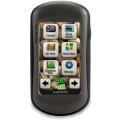
Outdoor navigation meets touchscreen simplicity in Dakota 20. This rugged, palm-sized navigator combines touchscreen navigation, high-sensitivity GPS with HotFix® satellite prediction, barometric altimeter, 3-axis electronic compass and microSD™ card slot in one affordable, power-packed punch.
Touch and Go
Dakota 20 makes outdoor navigation effortless with a tough, sunlight-readable, 2.6″ (6.6 cm) color touchscreen display. The interface is easy to use, so you’ll spend more time enjoying the outdoors and less time searching for information. Both durable and waterproof, Dakota 20 is built to withstand the elements; bumps, dust, dirt and water are no match for this rugged navigator.
Get Your Bearings
Dakota 20 has a built-in 3-axis electronic compass, which shows where you’re heading even when you’re standing still or not holding the device level. Its barometric altimeter tracks changes in pressure to pinpoint your precise altitude, and you even can use it to plot barometric pressure over time, which can help you keep an eye on changing weather conditions. And with its high-sensitivity, WAAS-enabled GPS receiver with HotFix satellite prediction, Dakota 20 locates your position quickly and precisely and maintains its GPS location even in heavy cover and deep canyons.
Find Fun
Get into paperless geocaching with Dakota 20 by quickly downloading up to 2,000 caches with information such as location, terrain, difficulty, hints and description — no more paper printouts and manually entered coordinates.
Explore the Terrain
Dakota 20 comes with a built-in worldwide basemap, so you can navigate anywhere with ease. Adding more maps is easy with our detailed topographic, marine and road maps, available on microSD™ card.
Share Wirelessly
Share your waypoints, tracks, routes and geocaches wirelessly with other compatible Dakota, Foretrex®, Oregon® and Colorado® devices. Just touch “send” to transfer your information to similar devices.
Get Connected
You’ve been busy exploring and now you want to store and analyze your activities. With a simple connection to your computer and Internet, you can get a detailed analysis of your activities and send tracks to your outdoor device using Garmin Connect™. This one-stop site offers an activity table and allows you to view your activities on a map using Google™ Earth. Explore other routes uploaded from more than 12 million customers and share your experiences on Twitter® and Facebook®. Getting started is easy, so get out there, explore and share.
Plan Your Next Trip
Take charge of your next adventure with BaseCamp™, software that lets you view and organize maps, waypoints, routes, and tracks. This free trip-planning software even allows you to create Garmin Adventures that you can share with friends, family or fellow explorers. BaseCamp displays topographic map data in 2-D or 3-D on your computer screen, including contour lines and elevation profiles. It also can transfer an unlimited amount of satellite images to your device when paired with a BirdsEye Satellite Imagery subscription.
Specifications
Physical & Performance:
|
| Unit dimensions, WxHxD: |
2.2″ x 3.9″ x 1.3″ (5.5 x 10 x 3.3 cm) |
| Display size, WxH: |
1.43″ x 2.15″ (3.6 x 5.5 cm); 2.6″ diag (6.6 cm) |
| Display resolution, WxH: |
160 x 240 pixels |
| Display type: |
transflective color TFT touchscreen |
| Weight: |
5.25 oz (148.8 g) with batteries |
| Battery: |
2 AA batteries (not included); NiMH or Lithium recommended |
| Battery life: |
20 hours |
| Waterproof: |
yes (IPX7) |
| Floats: |
no |
| High-sensitivity receiver: |
yes |
| Interface: |
USB |
Maps and Memory:
|
| Basemap: |
yes |
| Preloaded maps: |
no |
| Ability to add maps: |
yes |
| Built-in memory: |
850 MB |
| Accepts data cards: |
microSD™ card (not included) |
| Waypoints/favorites/locations: |
1000 |
| Routes: |
50 |
| Track log: |
10,000 points, 200 saved tracks |
Features and Benefits:
|
| Automatic routing (turn by turn routing on roads): |
yes (with optional mapping for detailed roads) |
| Electronic compass: |
yes (tilt-compensated, 3-axis) |
| Touchscreen: |
yes |
| Barometric altimeter: |
yes |
| Camera: |
no |
| Geocaching-friendly: |
yes (paperless) |
| Custom maps compatible: |
yes |
| Photo navigation (navigate to geotagged photos): |
no |
| Hunt/fish calendar: |
yes |
| Sun and moon information: |
yes |
| Tide tables: |
yes |
| Area calculation: |
yes |
| Custom POIs (ability to add additional points of interest): |
yes |
| Unit-to-unit transfer (shares data wirelessly with similar units): |
yes |
| Picture viewer: |
no |
| Garmin Connect™ compatible (online community where you analyze, categorize and share data): |
yes |
 HP LaserJet 4250/4350 series Q5942A Black Print Cartridge
1 × AED599.00
HP LaserJet 4250/4350 series Q5942A Black Print Cartridge
1 × AED599.00  Dell 500GB Near-Line SAS 6Gbps 7.2k 6cm (2.5") HD Fully Assembled
1 × AED1,499.00
Dell 500GB Near-Line SAS 6Gbps 7.2k 6cm (2.5") HD Fully Assembled
1 × AED1,499.00  Cisco PAP2T Internet Phone Adapter with 2 VoIP Ports
1 × AED199.00
Cisco PAP2T Internet Phone Adapter with 2 VoIP Ports
1 × AED199.00  Garmin GPSMAP 62st
1 × AED1,569.00
Garmin GPSMAP 62st
1 × AED1,569.00  04 3550600
 052 7036860


There are no reviews yet.