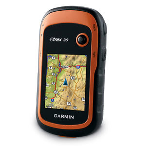
Rugged, Full-featured Handheld with GPS and GLONASS Combined
- 2.6″ sunlight-readable color screen
- High-sensitivity GPS and GLONASS receiver with quad helix antenna
- 4 GB of internal memory and a microSD™ card slot
- 250,000 preloaded caches for paperless caching from Geocaching.com

GPSMAP 64 features a 2.6″ sunlight-readable color screen that supports BirdsEye Satellite Imagery(subscription required) and Garmin Custom Maps. Rugged and waterproof, GPSMAP 64 uses a quad helix antenna for superior reception.
Explore the Terrain
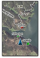
GPSMAP 64 comes with a built-in worldwide basemap with shaded relief so you can navigate anywhere with ease. With photo navigation, you can download geotagged pictures from the Internet and navigate to them.
Keep Your Fix
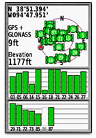
With its quad helix antenna and high-sensitivity, GPS and GLONASS, receiver, GPSMAP 64 locates your position quickly and precisely and maintains its location even in heavy cover and deep canyons. The advantage is clear — whether you’re in deep woods or just near tall buildings and trees, you can count on GPSMAP 64 to help you find your way when you need it the most.
Add Maps
Adding more maps to GPSMAP 64 is easy with our array of detailed topographic, marine and road maps. With 4 GB of onboard memory and microSD card slot, you can conveniently download TOPO 24K and 100K maps and hit the trail, plug in BlueChart® g2 preloaded cards for a great day on the water or City Navigator NT® map data for turn-by-turn routing on roads (see maps tab for compatibility). GPSMAP 64 also supports BirdsEye Satellite Imagery (subscription required) that lets you load satellite images onto your device and integrate them with your maps. In addition, the 64 is compatible with Custom Maps, a map format that allows you to transform paper and electronic maps easily into downloadable maps for your device, for free.
Find Fun
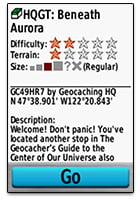
GPSMAP 64 supports paperless geocaching with 250,000 preloaded caches with hints and descriptions fromGeocaching.com, and has a 16-hour battery life. By going paperless, you’re not only helping the environment, but also improving efficiency. GPSMAP 64 stores and displays key information, including location, terrain, difficulty, hints and descriptions, which means there’s no more manually entering coordinates and paper printouts! Slim and lightweight, 64 is the perfect companion for all your outdoor pursuits.
Plan Your Next Trip
Take charge of your next adventure with BaseCamp™, software that lets you view and organize maps, waypoints, routes and tracks. This free trip-planning software even allows you to create Garmin Adventuresthat you can share with friends, family or fellow explorers. BaseCamp displays topographic map data in 2-D or 3-D on your computer screen, including contour lines and elevation profiles. It also can transfer an unlimited amount of satellite images to your device when paired with a BirdsEye Satellite Imagery subscription.
Quad helix antenna with GPS/GLONASS
Find your way with the first quad helix GPS receiver that tracks both GPS and GLONASS satellites simultaneously. When using them together, the receiver has the ability to lock onto 24 more satellites than using GPS alone, ensuring you can “lock on” to a position more quickly.
Preloaded Geocaches
Start caching immediately by choosing from the 250,000 preloaded geocaches fromGeocaching.com. Caches come complete with hints and descriptions to get you started in the right direction.
Extensive Map Support
With its microSD™ card slot and large internal memory, GPSMAP 64 lets you load a variety of maps, including TOPO 24K, BlueChart® g2, City Navigator NT® and BirdsEye Satellite Imagery (subscription required).
Dual Battery System
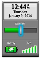
Go further with GPSMAP 64’s long-lasting 16 hour battery life. Works with 2 AA batteries or the the optional NiMH battery pack, which as an added bonus, can be charged while inside the device.
Physical & Performance:
|
| Physical dimensions |
2.4″ x 6.3″ x 1.4″ (6.1 x 16.0 x 3.6 cm) |
| Display size, WxH |
1.43″ x 2.15″ (3.6 x 5.5 cm); 2.6″ diag (6.6 cm) |
| Display resolution, WxH |
160 x 240 pixels |
| Display type |
transflective, 65-K color TFT |
| Weight |
9.2 oz (260.1 g) with batteries |
| Battery |
2 AA batteries (not included); NiMH or Lithium recommended |
| Battery life |
16 hours |
| Water rating |
IPX7 |
| Floats |
No |
| High-sensitivity receiver |
Yes |
| Interface |
USB and NMEA 0183 compatible |
Maps & Memory:
|
| Basemap |
Yes |
| Preloaded maps |
no |
| Ability to add maps |
Yes |
| Built-in memory |
4GB |
| Accepts data cards |
microSD™ card (not included) |
| Waypoints/favorites/locations |
5000 |
| Routes |
200 |
| Track log |
10,000 points, 200 saved tracks |
Features & Benefits:
|
| Automatic routing (turn by turn routing on roads) |
Yes (with optional mapping for detailed roads) |
| Electronic compass |
No |
| Touchscreen |
No |
| Barometric altimeter |
No |
| Camera |
no |
| Geocaching-friendly |
Yes (Paperless) |
| Custom maps compatible |
Yes |
| Photo navigation (navigate to geotagged photos) |
Yes |
| Hunt/fish calendar |
Yes |
| Sun and moon information |
Yes |
| Tide tables |
Yes (with optional Bluechart) |
| Area calculation |
Yes |
| Custom POIs (ability to add additional points of interest) |
Yes |
| Unit-to-unit transfer (shares data wirelessly with similar units) |
No |
| Picture viewer |
Yes |
| Garmin Connect™ compatible (online community where you analyze, categorize and share data) |
Yes |
- GPSMAP 64
- Lanyard
- USB cable
- Manual
 HP C9703A Magenta Toner Cartridge HP Color LaserJet 1500 & 2500
1 × AED369.00
HP C9703A Magenta Toner Cartridge HP Color LaserJet 1500 & 2500
1 × AED369.00  Kingwin HDM-231 4 X 2.5" To 3.5" Mounting Kit
1 × AED99.00
Kingwin HDM-231 4 X 2.5" To 3.5" Mounting Kit
1 × AED99.00  AVPro Edge AC-SC2-AUHD-GEN2 18Gbps HDMI Full Scaler/Interlaced/Progressive Frame Rate/Chroma EDID Manager
1 × AED3,299.00
AVPro Edge AC-SC2-AUHD-GEN2 18Gbps HDMI Full Scaler/Interlaced/Progressive Frame Rate/Chroma EDID Manager
1 × AED3,299.00  Speco Technologies SPE-HTD5TG 5MP HD-TVI Dome, IR, 2.8mm lens, Grey housing, Included Junc Box, TAA
1 × AED1,799.00
Speco Technologies SPE-HTD5TG 5MP HD-TVI Dome, IR, 2.8mm lens, Grey housing, Included Junc Box, TAA
1 × AED1,799.00  Eaton Metered Input Rack PDU 8.64 kW max 120/208V 24A 0U Three-Phase PDU
1 × AED9,699.00
Eaton Metered Input Rack PDU 8.64 kW max 120/208V 24A 0U Three-Phase PDU
1 × AED9,699.00  HP 2008 150W Advenced Docking Station for 6930 6510 8510 2230 87
1 × AED1,199.00
HP 2008 150W Advenced Docking Station for 6930 6510 8510 2230 87
1 × AED1,199.00 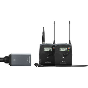 Sennheiser EW 100 ENG G4 Camera-Mount Wireless Combo Microphone System (A: 516 to 558 MHz)
1 × AED3,999.00
Sennheiser EW 100 ENG G4 Camera-Mount Wireless Combo Microphone System (A: 516 to 558 MHz)
1 × AED3,999.00  Gra-Vue XIO 9040XC-3U SDI Cross Converter for XIO Rackmount Frame
1 × AED13,199.00
Gra-Vue XIO 9040XC-3U SDI Cross Converter for XIO Rackmount Frame
1 × AED13,199.00  Toshiba PH3200U-1I72 2TB 3.5in 6Gbps 7.2K RPM Desktop SATA HDD
1 × AED599.00
Toshiba PH3200U-1I72 2TB 3.5in 6Gbps 7.2K RPM Desktop SATA HDD
1 × AED599.00  D-Link DES-3326SR Stackable Layer 3 Switch
1 × AED1,785.00
D-Link DES-3326SR Stackable Layer 3 Switch
1 × AED1,785.00  HP J9550A 24-port Gig-T v2 zl Module for E5400/E8200 series zl switches
1 × AED3,999.00
HP J9550A 24-port Gig-T v2 zl Module for E5400/E8200 series zl switches
1 × AED3,999.00  Cisco Business 350 Series CBS350-24S-4G - switch - 24 ports - managed - rack-mountable
1 × AED4,699.00
Cisco Business 350 Series CBS350-24S-4G - switch - 24 ports - managed - rack-mountable
1 × AED4,699.00 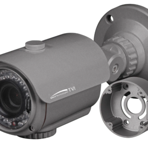 Speco Technologies SPE-HT7040T 2MP HD-TVI Bullet, IR, 2.8-12mm lens, Grey housing, Included Junc Box, TAA
1 × AED2,999.00
Speco Technologies SPE-HT7040T 2MP HD-TVI Bullet, IR, 2.8-12mm lens, Grey housing, Included Junc Box, TAA
1 × AED2,999.00  LOGITECH GAMING WHEEL DRIVING FORCE GT-NEW
1 × AED579.00
LOGITECH GAMING WHEEL DRIVING FORCE GT-NEW
1 × AED579.00  Dell 1.2TB 10K RPM SAS 6Gbps 2.5in Hot-plug Hard Drive
1 × AED4,019.00
Dell 1.2TB 10K RPM SAS 6Gbps 2.5in Hot-plug Hard Drive
1 × AED4,019.00  External SCSI Case HD68F LVD U320 - One 3.5" Bay - Refurbished
1 × AED499.00
External SCSI Case HD68F LVD U320 - One 3.5" Bay - Refurbished
1 × AED499.00 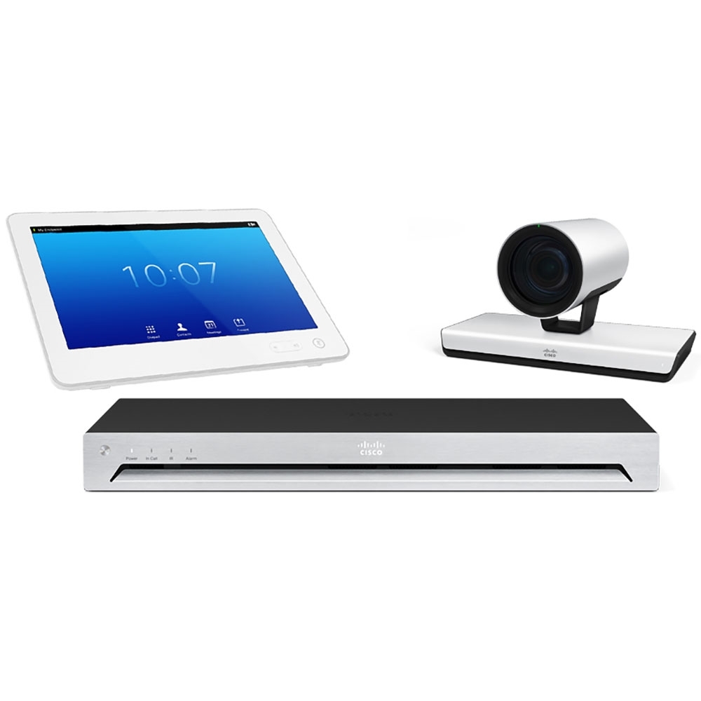 Cisco CTS-SX80-IP60-K9 SX80 codec with Precision 60 Camera, and Touch 10 bundle 1920 x 1080 Video (Live) - 2 x HDMI Out
1 × AED59,999.00
Cisco CTS-SX80-IP60-K9 SX80 codec with Precision 60 Camera, and Touch 10 bundle 1920 x 1080 Video (Live) - 2 x HDMI Out
1 × AED59,999.00  04 3550600
 052 7036860


There are no reviews yet.