No products in the cart.
 04 3550600
 052 7036860

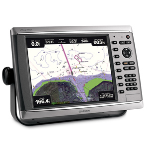
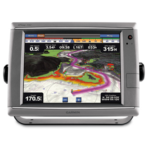
GPSMAP 750 is a stand-alone touchscreen chartplotter that brings a new level of functionality to your vessel. Featuring a brilliant 7-inch display, GPSMAP 750 puts all the information you need right at your fingertips. GPSMAP 750 is preloaded with marine charts for the UK and Ireland. In addition, GPSMAP 750 accepts radar input and offers full NMEA 2000® connectivity for greater convenience when adding extra sensors.
Explore the Seas
GPSMAP 750 contains preloaded coastal charts for the UK and Ireland. For all other areas, GPSMAP 750 has a worldwide basemap. GPSMAP 750 also features an internal, high-sensitivity GPS receiver for superior satellite tracking and quicker acquisition times.
Take Control by Touch
Input is easy with GPSMAP 750. Whether you’re changing course or simply reviewing information in front of you, the intuitive touchscreen interface enables simple operation. The unit also offers flexible brightness levels for daytime readability along with low-light dimming during night use. And with a widescreen display that’s rugged and waterproof, it’s made to perform in any situation.
Expand with Radar
Featuring a built-in radar port, GPSMAP 750 can be interfaced with Garmin’s line of affordable GMR™ marine radar systems. Whether you’re adding radar now or in the future, you’ll enjoy the convenience of “plug-and-play installation” as well as the power, range and high-definition targeting of our proven radar offerings.
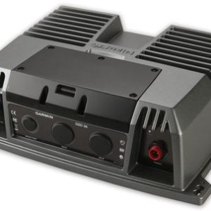
Add Sonar with GPSMAP 750s
GPSMAP 750s comes standard with a 1kW-capable sonar transceiver. This powerful sonar can help you define fish targets and underwater structures as far down as 610 metres (2000 feet) when used with a 1kW transducer¹.
Add Extras with BlueChart g2 Vision
With the optional BlueChart® g2 Vision SD card, you can add a whole new dimension of exceptional features to your chartplotter.
- MarinerEye view and FishEye view provide you with a 3-dimensional perspective of map information, both above and below the waterline.
- High-resolution satellite images and aerial photographs help you orient yourself in unfamiliar areas.
- Auto Guidance technology searches through all relevant charts to create a route you can actually follow — one that avoids obstacles, shallow water, buoys and other obstructions.
Physical & Performance: |
|
| Unit dimensions, WxHxD: | 8.8″ x 5.6″ x 3.1″ (22.4 x 14.2 x 7.9 cm) |
| Display size, WxH: | 6.0″ x 3.6″, 7.0″ diagonal (15.2 x 9.1 cm, 17.8 cm diagonal) |
| Display resolution, WxH: | 800 x 480 pixels |
| Display type: | WVGA display |
| Weight: | 2.48 lb (1.1 kg) |
| Waterproof: | yes (IPX7) |
Maps & Memory: |
|
| Basemap: | yes |
| Preloaded street maps: | yes |
| Ability to add maps: | yes |
| Accepts data cards: | SD™ card slot |
| Waypoints/favorites/locations: | 3,000 |
| Routes: | 100 |
Features & Benefits: |
|
| CANet® compatible: | no |
| Supports AIS (tracks target ships’ position): | yes |
| Supports DSC (displays position data from DSC capable VHF radio): | yes |
| Audible alarms: | yes |
| Tide tables: | yes |
| Sun and moon information: | yes |
| 3-D map view: | yes (with optional BlueChart g2 maps) |
| Dual-frequency sonar capable: | yes |
| Dual-beam sonar capable : | yes |
| Split-screen zoom: | yes |
| Split-screen sonar/gps: | yes |
| Ultrascroll® (displays fish targets at higher boat speeds): | yes |
| Fish Symbol ID (helps identify fish targets): | yes |
| AutoGain Technology (minimizes clutter, maximizes targets): | yes |
| Whiteline (indicates hard or soft bottom): | yes |
| Adjustable depth line (measures depth of underwater objects): | yes |
| A-scope (real time display of fish passing through transducer beam): | yes |
| Bottom lock (shows return from the bottom up): | yes |
| Water temperature log and graph: | yes |
| Water temperature sensor included: | yes |
Other: |
|
| Frequency: | dual freq: 50/200 kHz |
| Transmit power: | 1-kW RMS |
| Voltage range: | 10-32 Vdc |
| Maximum depth: | 2000 ft |


There are no reviews yet.