Garmin GPSMAP 526s 5-Inch Waterproof Marine GPS and Chartplotter (Without Transducer)
- Display Screen: 5″ VGA
- Resolution: 480 x 640
- Form Factor: Mountable
| Item Weight |
1.8 pounds |
| Product Dimensions |
6.4 x 2.9 x 5.9 inches |
| Item model number |
010-00772-02 |
| Display Size |
5 inches |
| Display Resolution |
480 x 640 |
The GPSMAP 526s is a compact chartplotter that features a high-resolution, super-bright 5″ (12.7 cm) VGA display along with an improved high-speed digital design for increased map drawing and panning speeds. It’s ready to go with a built-in, satellite-enhanced worldwide basemap. The GPSMAP 526s also accepts BlueChart® g2 Vision® cards (sold separately) for added features and functionality such as high-resolution satellite imagery, 3-D views and Auto Guidance technology.
Explore the Seas
The GPSMAP 526s comes ready to go with a worldwide basemap with satellite images in place of more traditional maps. The 526s also comes standard with a high-sensitivity GPS receiver for superior satellite tracking and quicker acquisition times. In addition, the GPSMAP 526s can receive U.S. graphical weather data via optional GXM™ 51 satellite receiver/antenna (sold separately). And with an SD™ card slot, it’s easy to add additional maps without connecting to a computer.
Add Extras with BlueChart g2 Vision
With the optional BlueChart g2 Vision SD card, you can add a whole new dimension of exceptional features to your chartplotter.
- MarinerEye view and FishEye view provide you a 3-D perspective of map information, both above and below the waterline.
- High-resolution satellite images and aerial photographs help you orient yourself in unfamiliar areas.
- Auto Guidance technology searches through all relevant charts to create a route you actually can follow — one that avoids obstacles, shallow water, buoys and other obstructions.
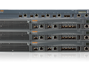 Aruba 7210, 4x 10GBase-X (SFP+), 1x 350W AC PS, Restricted Regulatory Domain Mobility Controller - US Version
1 × AED69,999.00
Aruba 7210, 4x 10GBase-X (SFP+), 1x 350W AC PS, Restricted Regulatory Domain Mobility Controller - US Version
1 × AED69,999.00  Edimax Ip Camera : Wireless 1.3 Mega Pixel Plug
1 × AED369.00
Edimax Ip Camera : Wireless 1.3 Mega Pixel Plug
1 × AED369.00  04 3550600
 052 7036860
")

There are no reviews yet.